Language
View Service
The OneAtlas Data View service allow users to easily access to images without having to download and maintain DIMAP products. This guide will walk you though using WMS and WMTS to stream on the fly.
Prerequisites: If you haven’t already, see our Authentication Guide for information on how to acquire an API key and generate tokens to access to our endpoints. If you would like to try the examples in this guide, ensure that GDAL Geospatial Data Abstraction Library is installed.
Preview Images
A preview is simple way to get a rapid insight of the imagery. The preview images include three bands (Blue, Red and Green), the pixel depth is 8 bits. A preview is neither orthorectified nor geolocalized. There are two kinds available:
| Kind | Description |
|---|---|
| Thumbnails | The thumbnail is a very reduced size version of the image. Its size depends of each image but is approximately 150 × 300 pixels. |
| Quicklook | The quicklook is a reduced size version of the image. Its size depends of each image but is approximately 2500 × 5000 pixels. |
The endpoints follow always the same pattern:
| Preview type | Endpoint |
|---|---|
| thumbnail | https://access.foundation.api.oneatlas.airbus.com/thumbnail/<image_id> |
| quicklook | https://access.foundation.api.oneatlas.airbus.com/quicklook/<image_id> |
To access a thumbnail or a quicklook you first need to perform a search in our Living Library to grab the corresponding id. You can see an example of a quicklook within our Search Guide. Alternatively we can grab the quicklook URL by inputting the sourceIdentifier into this cURL command:
curl -k -L --silent -X GET "https://search.foundation.api.oneatlas.airbus.com/api/v2/opensearch?sourceIdentifier=DS_PHR1B_201805071126173_FR1_PX_W004N43_0309_01462" |python -m json.tool | grep "/quicklook" \
    -H "Cache-Control: no-cache" \
    -H "Authorization: Bearer <access_token>"
Not available.
Not available.
Here you can see the quicklook URL returned:
"href": "https://access.foundation.api.oneatlas.airbus.com/items/<image_id>/quicklook",
To download the quicklook image you can use an additional request. You can also specify the width of the quicklook by using parameters at the end of the URL (e.g. ?width=xxx).
curl --silent -X GET  "https://access.foundation.api.oneatlas.airbus.com/items/<image_id>/quicklook" > quicklook.jpg \
  -H "Authorization: Bearer <access_token>"
Not available.
Not available.
Now we can retrieve detailed information such as the size of the image using the gdalinfo utilitary:
> gdalinfo quicklook.jpg
Driver: JPEG/JPEG JFIF
Files: quicklook.jpg
Size is 909, 735
Coordinate System is `'
Image Structure Metadata:
  COMPRESSION=JPEG
  INTERLEAVE=PIXEL
  SOURCE_COLOR_SPACE=YCbCr
Corner Coordinates:
Upper Left  (    0.0,    0.0)
Lower Left  (    0.0,  735.0)
Upper Right (  909.0,    0.0)
Lower Right (  909.0,  735.0)
Center      (  454.5,  367.5)
Band 1 Block=909x1 Type=Byte, ColorInterp=Red
  Overviews: 455x368, 228x184
  Image Structure Metadata:
    COMPRESSION=JPEG
Band 2 Block=909x1 Type=Byte, ColorInterp=Green
  Overviews: 455x368, 228x184
  Image Structure Metadata:
    COMPRESSION=JPEG
Band 3 Block=909x1 Type=Byte, ColorInterp=Blue
  Overviews: 455x368, 228x184
  Image Structure Metadata:
    COMPRESSION=JPEG
Full Resolution Images
The OGC (Open Geospatial Consortium) is an international not for profit organization committed to making quality open standards for the global geospatial community. These standards are made through a consensus process and are freely available for anyone to use to improve sharing of the world’s geospatial data.
In the frame of the OneAtlas Data service, the WMTS, WMS and WCS protocols are provided to ease the use and the display of imagery in desktop GIS applications (QGIS, ArcMap) or any web mapping platforms that provide WMTS, WMS or WCS support.
The protocols provide the access to OneAtlas data images referenced in the public catalog, as well as your processed products in your private workspace up to their full resolution.
There are three kinds of images available:
| Multispectral | - Multispectral images include three multispectral (color) bands (Blue, Red and Green), the pixel depth is 8 bits. - The product pixel size is 6m for SPOT images and 2m for Pléiades images. - Images with optimized true color rendering (Display) - adjusted luminosity and contrast and preserved color balance. - The images are orthorectified with a geolocation accuracy of 10m CE 90. |
| Panchromatic | - Panchromatic images include includes only one black and white band. - The pixel depth is 8 bits. - The product pixel size is 1.5m for SPOT images and 0.5m for Pléiades images. - The images are orthorectified with a geolocation accuracy of 10m CE 90. |
| Pan-sharpened - Available on the fly | - Pan-sharpened products combine the visual information of the multispectral data with the spatial information of the panchromatic data, resulting in a higher resolution 0.5-m color product. - The pixel depth is 8 bits. - The product pixel size is 1.5m for SPOT images and 0.5m for Pléiades images. - Images with optimized true color rendering (Display)- adjusted luminosity and contrast and preserved color balance. - The images are orthorectified with a geolocation accuracy of 10m CE 90. |
WMS, WMTS and WCS
WMS
The OpenGIS® Web Map Service Interface Standard (WMS) provides a simple HTTP interface for requesting geo-registered map images from one or more distributed geospatial databases. A WMS request defines the geographic layer(s) and area of interest to be processed. The response to the request is one or more geo-registered map images (returned as JPEG, PNG, etc) that can be displayed in a browser application. The interface also supports the ability to specify whether the returned images should be transparent so that layers from multiple servers can be combined or not.
WMTS
The Web Map Tile Service (WMTS) service conforms to the WMTS Simple profile norm. According the reference, this service provides a pyramid of tiles in two different projections: WebMercator (EPSG:3857) and Geographic (EPSG:4326), these will be discussed in further detail.
WCS
The OpenGIS® Web Coverage Service (WCS) provides an open specification for sharing raster datasets on the web. A WCS service returns data in a format that can be used as input for analysis and modeling. This is in contrast with the OGC Web Map Service (WMS), which only returns a picture of the data.
Streaming On the Fly
Note: This requires a streaming plan. See our Manage Contract Guide if you do not yet have a subscription.
If you have sufficient GB, OneAtlas Data will allow you to stream pansharpened imagery on the fly just by searching through our Living Library. The simple example below using the /opensearch endpoint retrieves everything within the Living Library:
curl -X GET \
  'https://search.foundation.api.oneatlas.airbus.com/api/v2/opensearch' \
  -H 'Authorization: Bearer <access_token>' \
  -H 'Cache-Control: no-cache' \
  -H 'Content-Type: application/json' \
var data = null;

var xhr = new XMLHttpRequest();
xhr.withCredentials = true;

xhr.addEventListener("readystatechange", function () {
  if (this.readyState === 4) {
    console.log(this.responseText);
  }
});

xhr.open("GET", "https://search.foundation.api.oneatlas.airbus.com/api/v1/opensearch");
xhr.setRequestHeader("Authorization", "Bearer <access_token>");
xhr.setRequestHeader("Content-Type", "application/json");

xhr.send(data);
import requests

url = "https://search.foundation.api.oneatlas.airbus.com/api/v1/opensearch"

headers = {
    'Authorization': "Bearer <access_token>",
    'Content-Type': "application/json"
    }

response = requests.request("GET", url, headers=headers)

print(response.text)
Note: Images which can not meet the Living Library criteria can not be streamed on the fly, you may only view thumbnails, quicklooks and order them. They can be filtered thanks to the following property
processingLevelwith the value ALBUM. The value SENSOR enables to filter images which can be streamed and meet Living Library criteria.
To learn how to search by AOI, resolution, id and more, refer to our Search Guide. Once you have ordered your product, you will retrieve your WMTS, WMS and WCS URLs:
"wmts": {
    "href": "https://access.foundation.api.oneatlas.airbus.com/api/v1/items/<image_id>/wmts",
    "name": "WMTS",
    "type": "WMTS"
},
"wms": {
    "href": "https://access.foundation.api.oneatlas.airbus.com/api/v1/items/<image_id>/wms",
    "name": "WMS",
    "type": "WMS"
}
"wcs": {
    "href": "https://access.foundation.api.oneatlas.airbus.com/api/v1/items/<image_id>/wcs",
    "name": "WCS",
    "type": "WCS"
}
We will look at how you can use these URLs in more detail further in the guide.
Streaming from Your Workspace
Your workspace provides your contract with an area of all purchased imagery. All users on the same contract will have access to the same workspace. These images will be in type bundle which will allow you to stream either Panchromatic or Multispectral images. If you wish to stream imagery already within your workspace, you can filter using your workspaceId:
curl -X GET \
  'https://search.foundation.api.oneatlas.airbus.com/api/v2/opensearch?workspaceId=<workspace_id>' \
  -H 'Authorization: Bearer <access_token>' \
  -H 'Cache-Control: no-cache' \
  -H 'Content-Type: application/json' \
var data = null;

var xhr = new XMLHttpRequest();
xhr.withCredentials = true;

xhr.addEventListener("readystatechange", function () {
  if (this.readyState === 4) {
    console.log(this.responseText);
  }
});

xhr.open("GET", "https://search.foundation.api.oneatlas.airbus.com/api/v1/opensearch?workspaceId=<workspace_id>");
xhr.setRequestHeader("Authorization", "Bearer <access_token>");
xhr.setRequestHeader("Content-Type", "application/json");

xhr.send(data);
import requests

url = "https://search.foundation.api.oneatlas.airbus.com/api/v1/opensearch"

querystring = {"workspaceId":"<workspace_id>"}

headers = {
    'Authorization': "Bearer <access_token>",
    'Content-Type': "application/json"
    }

response = requests.request("GET", url, headers=headers, params=querystring)

print(response.text)
Alternatively, you can do this in one cURL command bif you know the sourceIdentifier:
curl --silent -k -L -X GET "https://search.foundation.api.oneatlas.airbus.com/api/v2/opensearch?sourceIdentifier=DS_PHR1B_201805071126173_FR1_PX_W004N43_0309_01462" \
   -H "Authorization: Bearer <access_token>" \
   -H "Cache-Control: no-cache" \
   | python -m json.tool | egrep "href"
Not available.
Not available.
This will return all URLs related to the sourceIdentifier that you have provided:
"href": "https://access.foundation.api.oneatlas.airbus.com/api/v1/items/<image_id>/metadata",
"href": "https://access.foundation.api.oneatlas.airbus.com/api/v1/items/<image_id>/delete",
"href": "https://access.foundation.api.oneatlas.airbus.com/api/v1/items/<image_id>/quicklook",
"href": "https://access.foundation.api.oneatlas.airbus.com/api/v1/items/<image_id>/thumbnail",
"href": "https://access.foundation.api.oneatlas.airbus.com/api/v1/items/<image_id>/wms",
"href": "https://access.foundation.api.oneatlas.airbus.com/api/v1/items/<image_id>/wmts",
"href": "https://access.foundation.api.oneatlas.airbus.com/api/v1/items/<image_id>/wcs"
Panchromatic and Multispectral
By using the WMTS URL above, this will stream Panchromatic imagery by default. If you wish to stream Multispectral you can use the Metadata URLs returned in your workspace:
"imagesMetadata": [
    {
        "href": "https://access.foundation.api.oneatlas.airbus.com/api/v1/items/9c41e689-3069-409a-ace7-af8cc512223e/images/1e2cf2fa-449a-43fe-ae2e-60df4bbbe5f7/metadata",
        "name": "panchromatic",
        "type": "application/geo+json"
    },
    {
        "href": "https://access.foundation.api.oneatlas.airbus.com/api/v1/items/9c41e689-3069-409a-ace7-af8cc512223e/images/6950d957-58af-442d-ab3f-d684b917f423/metadata",
        "name": "multispectral",
        "type": "application/geo+json"
    }
  ]
You will need to amend your URL to fit the Multispectral metadata URL as follows:
# Example of WMS request for multispectral
https://access.foundation.api.oneatlas.airbus.com/api/v1/items/9c41e689-3069-409a-ace7-af8cc512223e/images/6950d957-58af-442d-ab3f-d684b917f423/wms

# Example of WMTS request for multispectral
https://access.foundation.api.oneatlas.airbus.com/api/v1/items/9c41e689-3069-409a-ace7-af8cc512223e/images/6950d957-58af-442d-ab3f-d684b917f423/wmts

# Example of WCS request for multispectral
https://access.foundation.api.oneatlas.airbus.com/api/v1/items/9c41e689-3069-409a-ace7-af8cc512223e/images/6950d957-58af-442d-ab3f-d684b917f423/wcs
Access Imagery from GIS Tools
The OneAtlas Data streaming services follows rigorously the OGC norm for its WMTS, WMS and WCS implementation. Consequently, the integration of our URLs in these GIS tools is straightforward.
QGIS
You can easily access the OneAtlas Data imagery with OSGeo's QGIS Desktop application. QGIS is an Open Source Geographic Information System (GIS) app licensed under the GNU General Public License. QGIS can act as a WMS, WMTS and WCS client. The procedure to view WMS/WMTS imagery is documented directly on the QGIS website.
In the menu _“Layer” / “Add Layer” / “Add WMS/WMTS Layer…” / “New”, you will need to provide your WMS/WMTS/WCS URL.
To ensure a secure experience, a username and password are mandatory to access to OneAtlas Data images. The credentials to use are listed in the table below:
| Username | APIKEY |
| Password | insert_your_api_key |
The resulting dialog box filled out should look like:

And the result in QGIS is:
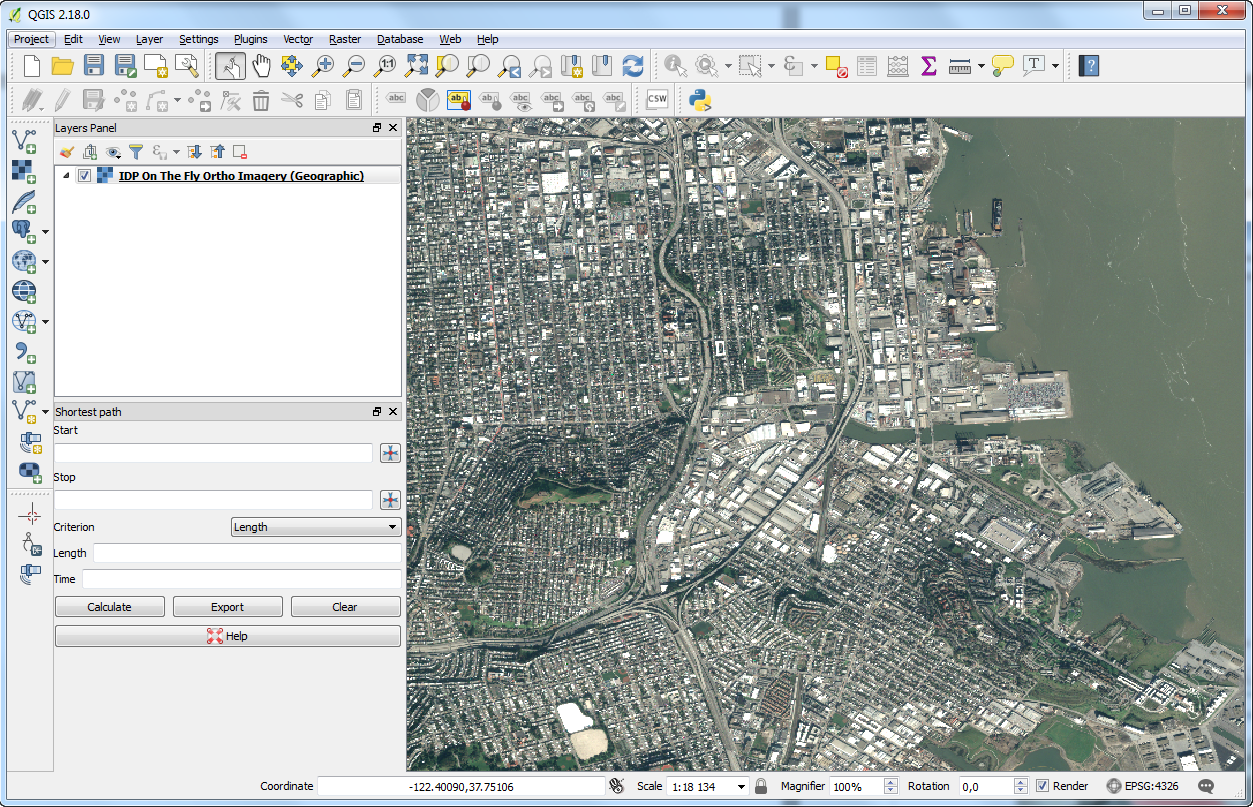
Note: if no tiles are returned, please ensure checkboxes : “Invert axis orientation (WMS 1.3/WMTS)” and “Invert axis orientation” are selected.
ArcGIS Enterprise
Go to your ArcGIS Enterprise instance and authenticate.
Click on the “Map” menu then on “Modify Map” on the upper right corner of the map, next to the “Sign In” button.
Select “Add Layer from the Web” and “A WMTS OGC Web Service” from the drop down list as type of data to reference. You will need to provide:
- The WMTS endpoint of the Living Library Image (see Search results)
- Credentials (an APIKEY) to be authorized to display the Living Library Image (see Authenticate Guide)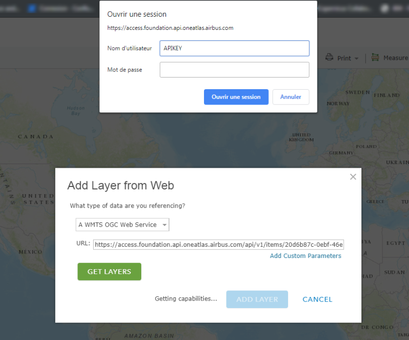 The layer name will be displayed in the ArcGIS Enterprise “Table Of Content” on the left hand side of the map. Meanwhile, the layer will display on the map.
Access Imagery from Your Own Code
As an example, we will use the following area of San Francisco International Airport:
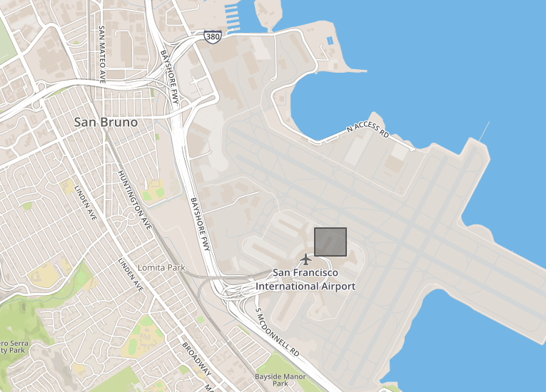
The coordinates of the bounding box to extract are:
| Longitude | Latitude | |
|---|---|---|
| Upper left corner | -122,385946512222 | 37,6203332456312 |
| Bottom right corner | -122,382202148437 | 37,6176733171484 |
The first step is to select the image from which we want to extract a subpart:
curl --silent -k -L -X GET   "https://search.foundation.api.oneatlas.airbus.com/api/v2/opensearch?itemsPerPage=1&startPage=1&relation=intersects&geometry=POLYGON((-122.38594651222229%2037.61767331714846%2C-122.3822021484375%2037.61767331714846%2C-122.3822021484375%2037.62033324563128%2C-122.38594651222229%2037.62033324563128%2C-122.38594651222229%2037.61767331714846))" \
  -H "Authorization: Bearer <access_token>" \
  -H "Cache-Control: no-cache" |python -m json.tool |egrep "href"
Not available.
Not available.
This example searches for an image with the specified polygon coordinates and extracts all URLs relating to this image (including WMS, WMTS and WCS):
"href": "https://access.foundation.api.oneatlas.airbus.com/api/v1/items/<image_id>/metadata",
"href": "https://access.foundation.api.oneatlas.airbus.com/api/v1/items/<image_id>/quicklook",
"href": "https://access.foundation.api.oneatlas.airbus.com/api/v1/items/<image_id>/thumbnail",
"href": "https://access.foundation.api.oneatlas.airbus.com/api/v1/items/<image_id>/wms",
"href": "https://access.foundation.api.oneatlas.airbus.com/api/v1/items/<image_id>/wmts",
Using WMS Protocol
You can use the WMS protocol to access to a subpart of an image. In this example we show a number of parameters needed to make a successful GetMap request:
curl -X GET \
  'https://access.foundation.api.oneatlas.airbus.com/api/v1/items/<item_id>/images/<Images_Id>/wms?REQUEST=GetMap&VERSION=1.3.0&LAYERS=layer_0&CRS=EPSG:4326&BBOX=<BBOXCoordinates>&WIDTH=600&HEIGHT=400&FORMAT=image/png'\
  -H 'Authorization: Bearer <access_token>' \
  -H 'Cache-Control: no-cache' \
  -H 'Content-Type: application/json' \
Not available
Not available
| https://access.foundation.api.oneatlas.airbus.com/api/v1/items/image_id/wms | This is the URL corresponding to the image and to the product type from which the request has to be done. |
| VERSION=1.3.0 | This is the most recent WMS request version. |
| REQUEST=GetMap | This is the request name. |
| CRS | This is the spatial reference value. The value could be EPSG:4326 or EPSG:3857 |
| BBOX | This is the ounding box for map extent. The value is 'minX, minY, maxX, maxY' in units of the SRS. |
| WIDTH / HEIGHT | This is the width or height of the requested image in pixels. |
| FORMAT=image/png | This is the requested image format. |
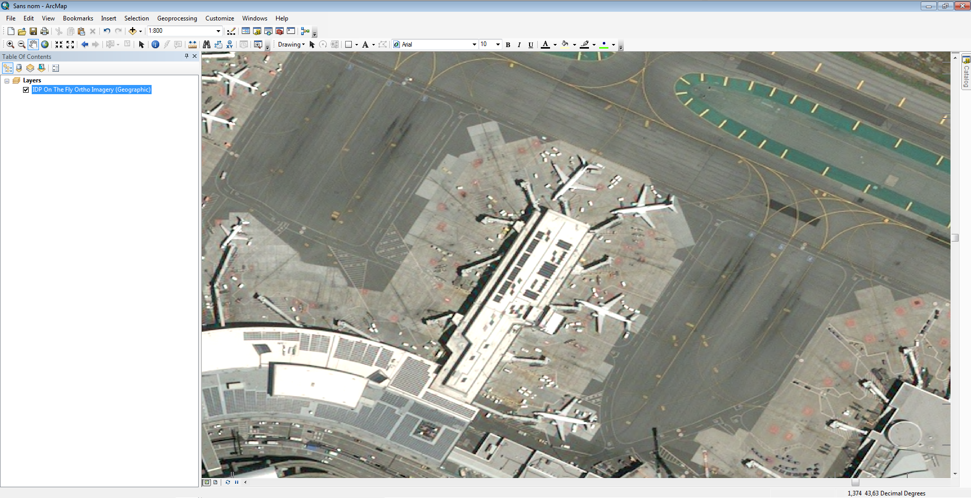
Here we can see the PNG result of the request above for the requested pixel size (600 × 400) satisfying our bounding box:
Using WMTS Protocol
This section details how to use the WMTS protocol from your own code. It’s a bit more complex that using the WMS protocol, but your efforts will be rewarded with better performance. To do so, you will need to convert the from geographic coordinates into tiles coordinates.
GetCapabilities
To retrieve the endpoint to access to a single tile, you should use the GetCapabilities file corresponding to the image from which you want to extract tiles.
The characteristics of the endpoint to access to the GetCapabilities are:
| API Endpoint | <wmts_url>?request=GetCapabilities |
| REST verb | GET |
| Authentication | Bearer access token |
| API Reference | View API |
Here is an example of a GetCapabilities request:
curl -X GET "https://access.foundation.api.oneatlas.airbus.com/api/v1/items/<image_id>/wmts?request=GetCapabilities"
  -H "Authorization: Bearer <access_token>"
  -H "Cache-Control: no-cache"
Not available.
Not available.
This will return an XML file with tiles. Below you can see an extract the XML file:
<TileMatrix>
  <ows:Identifier>12</ows:Identifier>
  <ScaleDenominator>68247.34668319309</ScaleDenominator>
  <TopLeftCorner>90.000000 -180.000000</TopLeftCorner>
  <TileWidth>256</TileWidth>
  <TileHeight>256</TileHeight>
  <MatrixWidth>8192</MatrixWidth>
  <MatrixHeight>4096</MatrixHeight>
</TileMatrix>
Get Tiles for a Geographic Tile Matrix Set
If you intend to get the tiles coordinates for the Geographic tile matrix set, you should use the formula below:
- x = [ (longitude + π) / (2 × π) ] × MatrixWidth
- y = [1 - [ (latitude + π/2 ) / π ] ] × MatrixHeight
Note: latitude and longitude should be in radians.
The Geographic tile matrix set is described as follows:
- CRS Name: urn:ogc:def:crs:OGC:1.3:CRS84 CRS84
- Top left corner: [ -180 , 90 ]
- Tile size: 256 × 256 pixels
| Zoom level id | Scale Denominator | Pixel Size (degrees) | Pixel Size (m)* | Matrix Width | Matrix Height |
|---|---|---|---|---|---|
| -1 | 559082264.0287178 | 1.40625 | 1 | 1 | |
| 0 | 279541132.0143589 | 0.703125 | 70312.5 | 2 | 1 |
| 1 | 139770566.0071794 | 0.351562500 | 35156.25 | 4 | 2 |
| 2 | 69885283.00358972 | 0.175781250 | 17578.125 | 8 | 4 |
| 3 | 34942641.50179486 | 8.78906250 × 10⁻² | 8789.063 | 16 | 8 |
| 4 | 17471320.75089743 | 4.39453125 × 10⁻² | 4394.531 | 32 | 16 |
| 5 | 8735660.375448715 | 2.19726562500 × 10⁻² | 2197.266 | 64 | 32 |
| 6 | 4367830.187724357 | 1.09863281250 × 10⁻² | 1098.633 | 128 | 64 |
| 7 | 2183915.093862179 | 5.49316406250 × 10⁻³ | 549.316 | 256 | 128 |
| 8 | 1091957.546931089 | 2.74658203125 × 10⁻³ | 274.658 | 512 | 256 |
| 9 | 545978.7734655447 | 1.37329101562500 × 10⁻³ | 137.329 | 1024 | 512 |
| 10 | 272989.3867327723 | 6.86645507812500 × 10⁻⁴ | 68.665 | 2048 | 1024 |
| 11 | 136494.6933663862 | 3.43322753906250 × 10⁻⁴ | 34.332 | 4096 | 2048 |
| 12 | 68247.34668319309 | 1.71661376953125 × 10⁻⁴ | 17.166 | 8192 | 4096 |
| 13 | 34123.67334159654 | 8.58306884765625 × 10⁻⁵ | 8.5831 | 16384 | 8192 |
| 14 | 17061.83667079827 | 4.29153442382812 × 10⁻⁵ | 4.2915 | 32768 | 16384 |
| 15 | 8530.918335399136 | 2.14576721191406 × 10⁻⁵ | 2.1458 | 65536 | 32768 |
| 16 | 4265.459167699568 | 1.07288360595703 × 10⁻⁵ | 1.0729 | 131072 | 65536 |
| 17 | 2132.729583849784 | 5.36441802978516 × 10⁻⁶ | 0.53644 | 262144 | 131072 |
* Approximation at the equator
The matrix width and height depends on the zoom level. You can pick the correct value using the table provided above. Be aware that the size of the tile matrix differs between the Geographic and the Web Mercator tile matrix set.
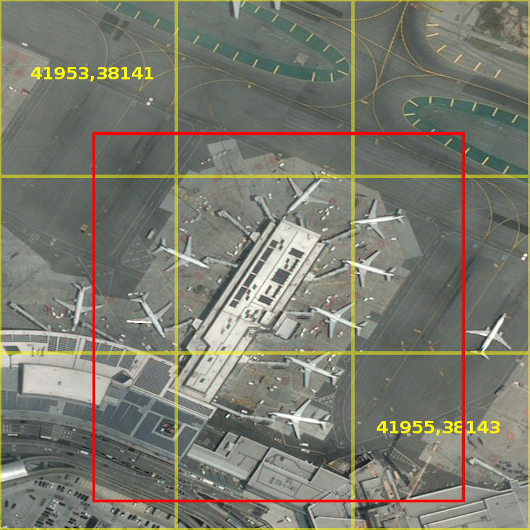
The request returns an XML response which is conformed to the OGC specification. By aggregating different elements such as the style, the tile matrix set with the ResourceURL value and integrating the tiles coordinates, you can access a single tile.
The below example contains the following elements which make up the URL to retrieve a tile:
- EPSG - in this example it is “EPSG4326”
- Zoom level - in this example this is “17”
- Upper left tile - in this example it is “41955”
- Bottom right tile - in this example it is “38143”
curl -X GET "https://access.foundation.api.oneatlas.airbus.com/api/v1/items/<image_id>/wmts/tiles/1.0.0/default/rgb/EPSG4326/17/41955/38143.png"
  -H "Authorization: Bearer <access_token>" \
  -H "Cache-Control: no-cache"
Not available.
Not available.
Here you can see the result displaying one tile:
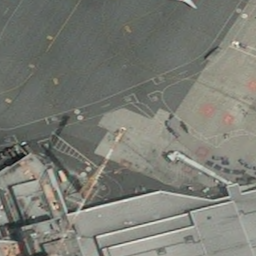
For this example the result is made up of 9 tiles. The overall size of the composite image is 728 (3 × 256) pixels per 728 pixels (3 × 256 pixels) and the returned BBOX exceeded the initial BBOX requested.
Geographic Converter (EPSG:4326)
Note: The converter uses input type degrees
To retrieve a URL for a single tile, you can use our simple Geographic converter below. You will require the following:
- The longitude and latitude for the top left and bottom right corner. These can be found within your AOI coordinates.
- The zoom level you would like to access. These are shown within the GetCapabilities XML result.
- The id of the image. You should have used this previously for the GetCapabilities result.
Get Tiles for a Web Mercator Tile Matrix Set
If you intend to get the tiles coordinates for the Web Mercator tile matrix set, you will have to first reproject the coordinates to the Mercator projection (from EPSG:4326 to EPSG:3857). Then you will be required to transform the range of latitude and longitude to 0 - 1 and shift origin to top left corner:
- n = 2 ^zoom
- xtile = n × ((longitude + π) / (2 × π))
- ytile = (1 - (log(tan(latitude) + sec(latitude)) / π)) / (2 × n)
Note: latitude and longitude are required in radians.
The Web Mercator tile matrix set is described as follows:
- CRS Name: urn:ogc:def:crs:EPSG:6.18:3:3857
- Top left corner: [ -20037508.3427892 , 20037508.3427892 ]
- Tile size: 256 × 256 pixels
| Zoom level id | Scale Denominator | Pixel Size (m) | Matrix Width | Matrix Height |
|---|---|---|---|---|
| 0 | 559082264.0287178 | 156543.0339280410 | 1 | 1 |
| 1 | 279541132.0143589 | 78271.51696402048 | 2 | 2 |
| 2 | 139770566.0071794 | 39135.75848201023 | 4 | 4 |
| 3 | 69885283.00358972 | 19567.87924100512 | 8 | 8 |
| 4 | 34942641.50179486 | 9783.939620502561 | 16 | 16 |
| 5 | 17471320.75089743 | 4891.969810251280 | 32 | 32 |
| 6 | 8735660.375448715 | 2445.984905125640 | 64 | 64 |
| 7 | 4367830.187724357 | 1222.992452562820 | 128 | 128 |
| 8 | 2183915.093862179 | 611.4962262814100 | 256 | 256 |
| 9 | 1091957.546931089 | 305.7481131407048 | 512 | 512 |
| 10 | 545978.7734655447 | 152.8740565703525 | 1024 | 1024 |
| 11 | 272989.3867327723 | 76.43702828517624 | 2048 | 2048 |
| 12 | 136494.6933663862 | 38.21851414258813 | 4096 | 4096 |
| 13 | 68247.34668319309 | 19.10925707129406 | 8192 | 819zoom_wm2 |
| 14 | 34123.67334159654 | 9.554628535647032 | 16384 | 16384 |
| 15 | 17061.83667079827 | 4.777314267823516 | 32768 | 32768 |
| 16 | 8530.918335399136 | 2.388657133911758 | 65536 | 65536 |
| 17 | 4265.459167699568 | 1.194328566955879 | 131072 | 131072 |
| 18 | 2132.729583849784 | 0.5971642834779395 | 262144 | 262144 |
You can use the same principle explained for the geographic tile grid. You must include the following elements within the URL:
- EPSG - in this example it is “EPSG3857”
- Zoom level - in this example this is “17”
- Upper left tile - in this example it is “41955”
- Bottom right tile - in this example it is “38143”
curl -X GET  "https://access.foundation.api.oneatlas.airbus.com/api/v1/items/<image_id>/wmts/tiles/1.0.0/default/rgb/EPSG3857/17/41955/38143.png" \
  -H "Authorization: Bearer <access_token>" \
  -H "Cache-Control: no-cache"
Not available.
Not available.
Web Mercator Converter (EPSG:3857)
Note: The converter uses input type degrees.
To retrieve a URL for a single tile, you can use our simple Web Mercator converter below. You will require the following:
- The longitude and latitude for the top left and bottom right corner. These can be found within your AOI coordinates.
- The zoom level you would like to access. These are shown within the GetCapabilities XML result.
- The id of the image. You should have used this previously for the GetCapabilities result.
© Airbus Defence and Space 2022. All rights reserved. Privacy Policy | Legal Information