Language
Glossary
Bundle (Panchromatic + Multispectral) Our Bundle product contains 2 different image files, each with a “native” resolution. 1 Panchromatic image (high-resolution, black and white). Pixel size: 0,5m for Pléiades and 1,5m for SPOT 6/7 Band: Black & white 1 Multispectral image (lower resolution, coloured: Red, Green, Blue and Near Infrared bands) Pixel size: 2m for Pléiades and 6m for SPOT 6/7 Bands: Red, Green, Blue, Near Infrared Example use cases: pansharpening, image correction (for imagery professionals), vegetation analysis, etc.
Display Display level products are generated based on a new algorithm based on the Reflectance product. The aim of the display option is to provide imagery that has been spectrally corrected and that is easy to display in true color in their software applications. Display processing is to be used when imagery needs to be immediately usable with optimized visual rendering.
Geographic projection A Geographic projection is a simple mapping projection based on a reference ellipsoid model of the Earth (WGS 84) to convert the coordinates to a planar system as angular coordinates (latitude / longitude). Main benefit: Preserve shape Best suited for wide coverage
GeoTIFF GeoTIFF files are free of any compression. GeoTIFF is based on the standard TIFF format that can be opened on most devices with no specific set up. The additional georeferenced information contained in the GeoTIFF file can be used on any GIS.
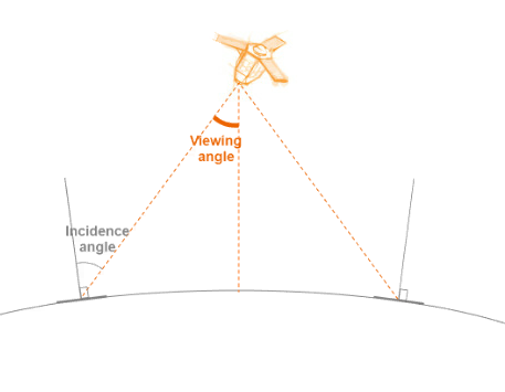
Incidence Angle 
JPEG 2000 Jpeg2000 files are smaller than GeoTIFF files. File compression has no impact on image quality, and is completely reversible. Jpeg2000 is an advanced format that can be opened via simple tools (GIMP, photoshop). Main benefit: Lighter image file Example use cases: post-processing, streaming, etc.
Orthorectification Orthorectification aims at applying geometric corrections that will display the image in a way that the pixels of the image are in an accurate position on the ground.
Panchromatic High-resolution, black and white image
Pansharpened Pansharpened results from the merging of the high-resolution Panchromatic and the lower resolution Multispectral imagery to create a single high-resolution colour image.
Reflectance Reflectance products are corrected from sensor calibration and systematic atmospheric effects. Clouds, cloud veil, haze, aerosol (pollution and sandstorm) remain. Images with a Reflectance processing are provided with the coefficients to reverse back to the Basic images, as well as the coefficients to convert into Display images.
Resolution Spatial resolution is defined as the pixel size of an image.
Tasking Tasking allows users to submit a satellite tasking request over an area of interest and to obtain the imagery they requested.
UTM projection The Universal Transverse Mercator (UTM) projection is also based on a reference ellipsoid model of the Earth (WGS 84). It differs from the Geographic projection in that it divides the Earth into 60 zones and projects each to the plane as a basis for its coordinates. Depending on your Area of Interest, you are proposed the most suitable zones for your projection. Main benefits: Preserve distance and area Native metrics (meters) Best suited for small areas
© Airbus Defence and Space 2022. All rights reserved. Privacy Policy | Legal Information